
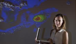
Rowena Lohman
Developing new ways to see under the surface
One of Rowena Lohman’s fondest memories of childhood is stopping at every cinder cone and rock outcrop visible from the highway on the 1000-mile route between her home in Southern California and her grandparents’ home in Colorado. “My dad was in computer sciences,” says Lohman,” but he really should have been a geologist.” This is something Lohman’s children will never have to say about her. She is an associate professor of Geophysics and Tectonics in the Department of Earth and Atmospheric Sciences at Cornell and deeply enjoys her choice of field.
Lohman’s primary research interests are earthquake physics, inverse theory, satellite remote sensing using Interferometric Synthetic Aperture Radar (InSAR), finite element modeling, ground displacements associated with both human and natural causes, the tectonics of southern California, Louisiana, the Cascadia subduction zone, and Iran, and the effects of land use change on observations of ground deformation and other remote sensing observations.
“This is such a good time to be in this field,” says Lohman. “A satellite is scheduled to launch in the next few years that will provide five- to ten-times the data we get currently. Our field is preparing for a flood of data.” This flood of data is something Lohman is looking forward to – but large volumes of data come with new types of noise and other problems. Lohman has many years of experience programming, examining InSAR data, and, in her words, “tinkering with techniques that will allow us to use data better.”
Using satellite data to better understand the Earth was not always Lohman’s goal. At one point in high school, she thought she wanted to be an architect—(this, in spite of the cindercones and outcrops.) But then one day she was walking down the hallway of her school and saw a flyer on the wall for the Juneau Ice Field Research Program. Lohman applied, was accepted, and had a life-changing experience. During her summer in Alaska she learned some linear algebra and set her mind on going to college to study Geology.
Originally, Dartmouth was her first choice for an undergraduate geology degree, but then she visited Caltech and met with Barclay Kamb. Kamb was one of the first geophysicists to travel to Antarctica and study the movements of ice sheets. When Lohman met with Kamb she talked about her experiences in Alaska and he promised her that if she came to Caltech, she would be able to go to Antarctica and do research. Who could say no to that? "So, I went to Caltech; Barclay Kamb was my advisor; and sure enough I did go to Antarctica…and I got to dig a lot of snow pits,” says Lohman with a wry smile. At Caltech, Lohman majored in Geological and Planetary Science and was one of only two students in the major.
Once she had her undergraduate degree, Lohman decided to stay at Caltech for her Ph.D. Her timing was excellent as she joined the lab of Professor Mark Simons. Just as Lohman started working with Simons, the radar technique known as InSAR was taking off. InSAR stands for Interferometric Synthetic Aperture Radar and it is used in geodesy—studying the shape of the Earth--and in remote sensing. Using InSAR, researchers could for the first time measure surface deformation in the millimeter range without having to place sensors on the ground. After earning her doctorate, Lohman was a post-doctoral researcher at Woods Hole Oceanographic Institution and NASA’s Jet Propulsion Lab.
Lohman joined the faculty at Cornell in the summer of 2007. Since coming to Cornell she has continued her work using satellite-based remote sensing observations of ground deformation before and during earthquake sequences. She has also worked to develop methods for taking greater advantage of the vast and quickly-growing volume of imagery available from international satellite platforms. Lohman understands that data is no good without the means to make efficient use of it. This has led her to be active in efforts to improve researcher access to satellite remote sensing data and numerical modeling tools to put the data to good use.
If her research efforts are successful, Lohman will increase our understanding of how the surface of the Earth moves in response to the things that are happening under the surface. Questions about the movement of the surface used to be limited to the basic idea “did the land move up or down in a given time frame?” With better imaging techniques and more data being collected, the questions we can ask are now much more nuanced. Factors like soil moisture content, tree height, and land use can all be taken into account to give a much more detailed understanding of the movements at the surface of the Earth.
Lohman also hopes to build a greater understanding of how all the things people do at or below the surface impact seismicity. “Sometimes surface deformation precedes earthquakes, particularly in volcanic regions” says Lohman, “but usually it doesn’t. Understanding the difference is very important.” Excavating mines, tapping into aquifers, building dams to create reservoirs, hydrofracking, CO2 sequestration, deforestation, and urban development all deform the surface—some very slowly and other fairly quickly. Collecting data on these deformations and analyzing the data as it relates to earthquakes can give researchers a better idea of how human activities affect seismicity. This idea has been in the news a lot lately due to swarms of earthquakes in the normally seismically inactive bedrock of Oklahoma.
With her research, Lohman hopes to increase what we know about the planet we live on. “Cornell’s Department of Earth and Atmospheric Sciences (EAS) is so strong,” says Lohman. “It is a great place to be. We have people working in the area of geodesy and others focused on seismicity and because it is such a collaborative place, we can bring these things together in a way to that will greatly increase what we know about the Earth.”